
California (Northern) Gold and Gems (Then and Now)
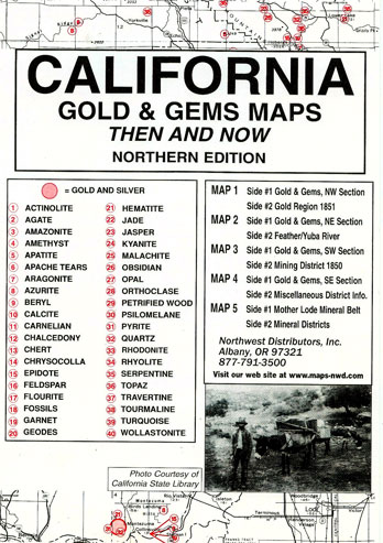
California Gold & Gems Maps: Then and Now (Northern Edition) is a package of 5 maps printed on both sides. This package includes:
Map #1, side 1 is of the NW Section. Side 2 is a map of 1851 showing the gold regions
Map #2, side 1 is of the NE Section. Side 2 is a map of the Feather/Yuba River
Map #3, side 1 is of the SW Section. Side 2 is a map of 1850 mining district
Map #4, side 1 is of the SE section. Side 2 contains miscellaneous district info
Map #5 is a map of the Mother Lode Mineral Belt. Side 2 is of the mineral districts
This package is a comprehensive collection of maps intended to assist the rockhound in locating 40 gem sites. The source of information has been taken from numerous publications. All known types of rock and gem deposits could not be included because of the numerous types and locations which would be overwhelming. Some of the reported gold and gold districts are included as early as 1850. The first report of gold in California was published in Spain in 1510. California was believed to be an island north of Mexico where gold and precious stones were abundant. Gold was actually mined in California as early as the late 18th century but the "rush" did not begin until the discovery at Sutters Mill in 1848 and was primarily located in the northern section of the state. Rock and gem collecting in California is virtually unlimited as illustrated by the key symbols on each USGS map section. A few counties that host exciting deposits are: Siskiyou, Trinity, Tehama and Plumas. All rockhounds, history buffs, amateur prospectors and treasure hunters living in California (or planning a visit) will want to own California Gold & Gems Southern Edition as well as both the northern and southern editions of California Ghost Towns/sites: Then and Now -- must have companion titles! Rock and Gem collecting in California is virtually unlimited as illustrated by the key symbols on each USGS map section. A few counties that host exciting deposits are as follows: Siskiyou, Trinity, Tehama and Plumas. The early maps included in this publication were located in various archival collections. The primary sources were the National Archives and the California State Library. The U.S. Geological Survey supplied the featured modern map. The design is planietric for clarity. All maps in the series are in packages measuring 6.5" by 9.5". The very readable maps measure 17-1/2" by 23".
Map: 6 pages
Publisher: Northwest Distributors (January 1, 2002)
Language: English
Product Dimensions: 9.5 x 6 x 0.4 inches